jueves, 28 de marzo de 2019
ANALYZING AND DESCRIBING POPULATION PYRAMIDS
A population pyramid is a traditional way of visualizing and explaining the age structure of a society. It is a graph that shows the structure of a society by sex and age at a given time and place.
The pyramid we are analazing shows the demographic represent the structure of a city in Germany in the 2012.
Observing the sex ratio we can say that more boys than girls are born. Sex ratio matches at the age of 64-69. When looking at the pyramid is clear that woman have a higher life expectancy than man, the reason for that might be that years ago women didn´t worked or the works where more easy and less hard that mens.Other reason is that women stayed at home taking care of the childrens while mens where the most time outside working.
With regard to the age structure of the pyramid we can say that…
The shape of the pyramid shows that birth rates and death rates are both low, stabilizing total population growth, countries have experienced significant economic and social advances allowing for reduced family size in relation to decades prior.
In addition, the structure of the pyramid exhibits high births rates between the 1967 and 1948 because in (high/low birth rates) (high/low death rates)…
The age group with a large njmber of people is 60-64 that means that…
The 45-49 interval shows a bump due to…
There is a notch in the 1973-1977 years related to strong economies, highly educated citizens, ample healthcare systems, the migration of people from rural communities to cities, and expanded employment opportunities for women.
The consequences of the demographic structure of the pyramid are…
Among the measures that can be applied to dela with… we can mention…
According to the data shown, we can predict that the demographic evolution of Germany will be…
LIFE EXPECTANCY
TOP 10 COUNTRIES WITH THE LOWEST LIFE EXPECTANCY
The countries with the lowest life expectancy hat are show in the maps
are:Sierra
Leone, Angola, Central African Republic, Chad, Côte d´Ivoire, Lesotho,
Nigeria, Somalia, South Sudan and Cameroon.
There are very notable differences between developed and underdeveloped
countries. Some of the most common factors of mortality in these
countries are; absence of vaccines, bad nutrition and poor education in
children under ten years.
Regarding to the time of being mother, motherhood will be different
between the two countries, it would have difficulties. Finally talking
about teenagers and adults, the type of food, the illnesses, the
lifestyle are relevant. Many food they eat, most of it comes from
animals that have diseases that affect human. They live in shanty
villages surrounded by lot of bacterias and viruses because the lack of
human rights, money and medical advantages.
TOP 10 COUNTRIES WITH THE HIGHEST LIFE EXPECTANCY
The countries with the highest life expectancy that are show in the maps
are: Japan, Switzerland, Singapore, Spain, Australia, Italy, Iceland,
Israel, France and Sweden in the order in this order.
First, as I explained before, we can analyse gender in those countries,
and conclude that women live more than men, for biological, genetic and
historic causes.
On the other hand, regarding to prenatal and childhood conditions we can
argue that in developed countries such as this ones, are better.
But there are more reasons that make life expectancy grow, like the
marital status or socioeconomic, or the medical technology, that are
very important. But the main factor which affects mortality is
lifestyle, that is much better in developed countries.
sábado, 9 de marzo de 2019
BARCELONA

The city plan shows a orthogoal layout. The medieval city was surrounded by a wall that was done two times, the first one is destroyed and we can´t see it but the second one we can see. The main buildings of this city are the monastery of Sant Pau del Camp
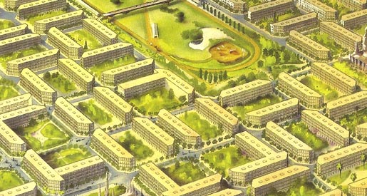
he first plan for the extension of Barcelona came from a Catalan civil engineer, Illdefons Cerdà. Cerdà’s plan was revolutionary for its time, as it focused on planning for hygiene and ease of mobility and transportation in a grid like structure. To increase hygiene, Cerdà drew from 19th century hygienist theories and planned the city blocks of the extension to be 113.3 by 113.3 m2 in order to optimize the living standards by allowing a 6 m2 volume of air per person. To increase mobility and transportation, Cerdà planned for each corner of a block to be cut in a chamfer, or rounded, planned very large street widths of 35 m, and included big avenues from 50 to 80 m wide at the main ports and gates of the city. The streets were divided into two parts, one for vehicles and one for pedestrians. In addition to hygiene and transportation, Cerdà focused on increasing the green spaces and gardens in every block of the city, almost like compact garden-city model. The main goal of Cerdà’s plan was to allow goods and raw materials to be easily transported around the city, a necessity for an industrializing city.
In addition to the planning for the layout of the extension, Cerdà also included an economic plan and the bylaws necessary for his plan to be implemented. The construction of Cerdà’s wide streets involved the use of many expropriations and compensation to be paid for the expropriations. Cerdà suggested the urbanization and building process of the Extension should be handed over to a large private enterprise to manage this expropriation. Cerdà also included very strict bylaws in order to ensure his living standards were being met. Buildings had to use less than 50% of the block’s surface, and could only use two of the block to allow space for gardens. There was a 20 m height limit as well as a 15 to 20 m depth limit.
Cerdà’s plan faced strong opposition particularly from architects and conservative parties. The architects first criticized Cerdà’s grid-like structure as monotonous and lacking creativity. The architects, most notably Antonio Rovira, wanted to develop the extension in a concentric way in order to promote class separation. Rovira’s plan focused on a hierarchical extension from the axis of the Passeig de Gràcia, already used by upper class and Catalan bourgeoisie. Cerdà’s plan was also criticized for its large use of expropriations for the wide streets. Rovira’s plan only used 10 to 15 m streets, therefore reducing the number of expropriations. The Barcelona city council also opposed the use of a private enterprise to manage the expropriations as they feared the project would grow out of their control.
The final criticism focused on Cerdà’s use of the old city from before the walls were demolished. Cerdà considered the extension as a foundation of a new Barcelona, and included plans to develop a new city center, the Plaça de les Glories Catalanes (clearly defined in the 1859 plan at the intersection of the major avenues), whereas Rovira planned to continue urbanization in a radial extension from the old city. Old city property owners feared that Cerdà’s plan would devalue their property and cost too much in expropriations, therefore they favored Rovira’s plan.
One of the main achievements of Cerdà’s plan was the construction of one of the three big avenues, the Via Laietana, to connect the port and the gates of the city. Controversy surrounded the construction of the Via Laietana because it divided one of the most densely populated areas of the old city, and it opened up the street widths to reduce potential blockading in strikes; however the construction was finished in 1926. Although Cerdà’s plan did not reach his intended level of completion, evidence of his plan can be seen today in Barcelona through the existence of the numerous trees along the sidewalks, the chamfers at each end of the building blocks, and the wide streets.
viernes, 8 de marzo de 2019
Suscribirse a:
Comentarios (Atom)